Street history - Robert Street
Lead researcher Chris Nichols
Download the Robert Street history as a .pdf (1.6Mb)
Introduction
Robert Street is situated between North Road and Gloucester Road and is mainly a residential street, as it has been throughout its history. The first houses were built between 1835 and 1841 built upon land which was in the Second Furlong of the North Laine which can be seen on the 1792 Terrier map.
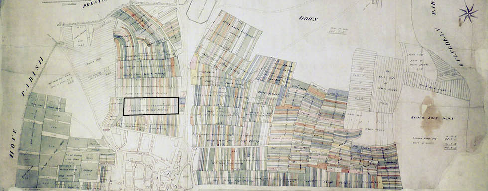
1) Terrier map of Brighton, 1792 (Second Furlong here shown framed). Image courtesy of East Sussex Record Office. Enlarge
Development
The Terrier also offers detailed ‘close-ups’ of the Pauls and ownership records (apportionment lists) for them. A close-up of the Second Furlong and a section of its apportionment list are reproduced as pictures 2 and 3.
Picture 2 clearly shows the furlong divided into its pauls (strips). The number on each strip refers to the owner of the paul. Owners can be identified by reference to the relevant apportionment list, which provides details of the freehold landholding at the time. Robert Street would appear to be strips eight and nine on the Terrier map. From the section of the apportionment list shown in picture 3, it can be seen that eight pauls of land were owned by Charles Scrase Dickens and four by Thomas Read Kemp. Other land in the immediate vicinity was owned by the Duke of Dorset (eight Pauls) and Kemp again, another eight pauls. This is the position in 1793 but it is still over forty years before Robert Street is actually built. Why?
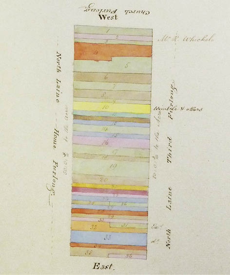
2) Close up of the Second Furlong, 1792. Image courtesy of
East Sussex Record Office
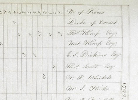
3) Detail from the 1792 Terrier’s apportionment list showing
landholding interests. Image courtesy of East Sussex
Record Office
The best explanation of the development of the First and Second Furlong is found in “Georgian Brighton” by Sue Berry.
“By 1808 a street pattern had emerged on the First Furlong… Building had also begun on the Second Furlong where St George’s Place,Cheltenham Place and Kensington Gardens were in progress. Jubilee Street was emerging and had a candle factory operating by 1809. She continues ,”By 1818 stabling for horses in the town,cow houses and market gardens were disappearing and being replaced by small processing businesses.”
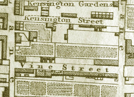
The 1826 J Pigot-Smith map of Brighton, picture 4, shows a formal garden in the area that was to become Robert Street. Sue Berry explains that;
“Having bought his long and narrow stretch of land, which normally consisted of between two and five paul pieces, the developer would lay a road straight down its entire length, either down the middle… or along one side.”1
This would appear to be the case for Robert Street’s development, where a straight road was laid out through a formal garden.
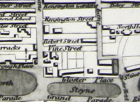
The 1845 “30 chains” map from Hove Library provides further information about the development of the street. In this, Robert Street can be seen between Kensington Street and Vine Street and there do not appear to be any houses. Both the 1841 Census and mid 1840’s street directories however, indicate that the street was completed on the eastern side by 1845. It is not unusual for the information on maps to differ from what is found in the directories or in the census and other sources. Robert street was not one of the more ”fashionable “ streets. Map makers recognised this fact and did not produce detailed up to date plans of these streets because there would be few buyers of the maps in these streets.
The 1847 map, held at the Brighton History Centre, would seem to back-up the idea that map makers often took some time to catch up on rapidly changing area detail. Once again the street is not shown fully developed on the eastern side even though there is documentary evidence to the contrary.
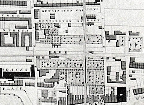
4) Detail of 1826 J Pigot-Smith map. Image courtesy of the
Royal Pavilion, Libraries and Museums, Brighton and Hove
5) Detail from the 1845 “30 chains” map of Brighton and
Hove. Image courtesy of the Royal Pavilion, Libraries and
Museums, Brighton and Hove
6) Detail from the 1847 map of Brighton and Hove. Image
courtesy of the Royal Pavilion, Libraries and Museums,
Brighton and Hove
Ownership
Very usefully, the deeds of one house exist – number twenty-five – at East Sussex Record Office (ESRO) in Lewes. The deeds first mention an indenture dated Christmas Day 1822 “made between Thomas Read Kemp Esquire of the first part, George Wigney Esquire of the second part and William Turner, Gentleman, of the third part.”2 There are records of six more indentures made between 1827 and 1833, these are to raise money for the building of the street, and the name, which appears on most of them, is George Cheesman Childrens (born in 1789 and also known as George Cheesman senior and George Cheesman the elder. George was the founder of the Cheesman building firm who were located in Kensington Street for many years.3)
In 1837 there is a record of the conveyance of two pieces of land for the building of 25 and 26 Robert Street between George Cheesman Childrens and Mr James Lambert for £105. This fits Berry’s notion of there being a wait involved in the building of these streets. The land signed over to Lambert was described in the deeds as;
“All that piece of land situate on the east side of Robert Street in Brighton aforesaid containing from North to South thirty feet and from East to West twenty five feet belonging to or in the occupation of Elijah A.West on the North to a messuage or tenement and other hereditaments lately conveyed to Willam Gillam on the South.”4
Two days later, on the 26th March, Lambert is recorded as borrowing £300 from Sarah Duke to help finance the building of these two houses. The deeds continue;
“All those two messuages or tenements, hereditaments and premises lately erected and built by or at the expense of the said John Lambert and now standing and being on the said pieces of land or on some part thereof, and numbered or intended to be numbered “25” and “26”in Robert street aforesaid.”5
The further history of the deeds of 25 Robert street is more involved - it was sold to a Mr Joseph Bates for £100 in 1840 and the mortgage was transferred to secure £120 in 1853 and again in 1864. This was common practice at the time since mortgages were often transferred between wealthier members of Brighton society. Suffice it to say that the freehold owners of these houses very seldom lived in the houses and they were rented to the artisan classes who inhabited these streets. It would seem that in 1837 the northern part of the street was developed.
Two other maps show the street’s development, one from 1870 and the 1875 Ordnance Survey map. This map shows the individual buildings in the street. It is possible to see a large area on the western side of the street was designated a timber yard backing onto Kensington Street.
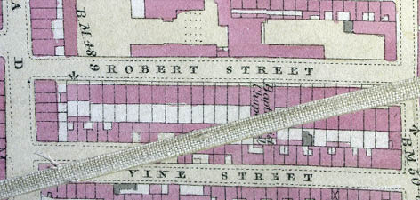
7) Detail from the 1875 OS map of Brighton and Hove.
Image courtesy of the Royal Pavilion, Libraries and
Museums, Brighton and Hove
Amenities and alterations
Unfortunately at this time it has not been possible to establish when Robert Street first had gas, electricity and telephone lines installed. This is something which needs further investigation. However it is known that the main thoroughfares of Brighton, thanks to the Brighton Commissioners, had gas lighting from 1825.6
The houses were gradually improved in the early and middle part of the twentieth century, the only record of this is a planning application made in March 1964 for an inside toilet and bathroom at number 8, though we know that all the houses would have eventually been improved in the same way.7
Notable buildings
The Jireh Strict Baptist Chapel, which can be seen clearly marked on the 1875 map above, was originally constructed to offer basement and two floors above ground. Picture 8 illustrates the original two stories above ground, albeit with later modifications. A third floor was added in 1898 and the building is seen in this form today, standing in the middle of the eastern side of the street. It was built in 1846 and Berys J.M. Shipley describes it as being “Regency in style with pilasters and a stucco finish,”8 in her book The Lost Churches of Brighton and Hove. Shipley goes onto discuss the building of Baptist Chapels during a period when many fine Anglican churches were being built in the town by the Wagner family.
“The Baptists (and Strict Baptists) built many small chapels often named Salem, Jireh, Bethesda, Providence, Ebenezer etc in the older and more central parts of the town. They would have been mostly privately endowed by groups of people often wishing to promote an individual pastor of their choice.”9
The Baptist Union Manual for 1853 mentions that the Jireh Chapel was established in 1842 (however there is no mention of the chapel in the local street directories until 1845). The same manual, for 1846, lists a J. Tant as minister, this may have been an error as W. Tant is listed as the minister for 1847 and 1848 in the Kelly’s Directory. We are indebted to Emily Burgoyne of the Regent’s Park College and David Woodruff of the Strict Baptist Historical Society for the information on the Chapel.
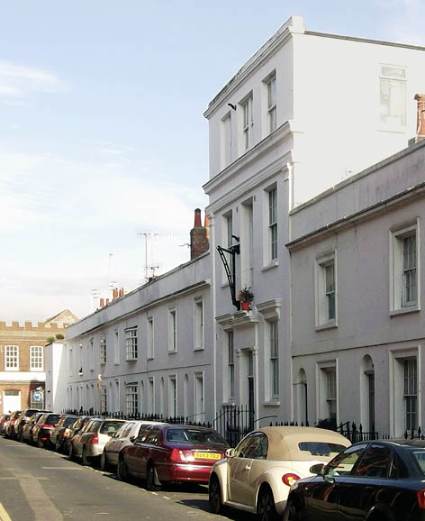
8) A contemporary photograph of Robert Street, the two stories
of the original Jireh Chapel can be seen, beneath the
third storey added in 1898
Non-Conformist churches are not legally obliged to lodge their records with the local record offices in this country, unlike the Church of England. There was a Jireh Chapel in Lewes as well but there does not seem to be any connection between the two, and despite the long history of non-conformity in both Brighton and Sussex it been difficult to research the chapel. More exists on other strict baptist chapels like the Salem Chapel in Bond Street, which was not demolished until 1974, the Ebenezer Chapel in Richmond Hill and the Galeed Chapel in Gloucester Road. Contemporary sources and in particular John Sawyer’s The Churches of Brighton published in 1897 mentions the Jireh Chapel but do not go into any further detail. Further discussion with David Woodruff has led to the discovery that the chapel was also referred to as a Calvinistic Strict Baptist Chapel, meaning it only baptised those who made a profession of faith in the Lord Jesus Christ, i.e. they did not baptise babies and young children.
Perhaps the most reliable early evidence about the chapel is the Ecclesiastical Census,10 which was held for the only time in 1851. This stated:
Jireh Baptist Chapel was formed in 1845
250 seats (100 free, remainder had pew rents paid)
Morning congregation 250
Evening congregation 240
Thomas Dray, minister, 32 Ivory Place Brighton
The chapel seems to have been very well attended and there was a demand for further services during the week, the 1856 Folthorps Directory states that the services were at 11am and 7am on a Sunday and at 7pm on a Monday and Wednesday. This pattern of services continued for a number of years, the 1877 Pages Directory mentions services at 11am and 6.30pm on a Sunday and Wednesday at 7pm. In the 1890 Directory there is no longer a Wednesday service listed. Towner’s Directory for 1897 states that there is a “morning service only, from 11 ‘till 12 when fine,” and the last mention of the chapel is in the Kellys directory for 1898 but it would seem most likely that the chapel closed during 1897. The building plan to the right evidences a major change of use early in 1898.
The Reverend Thomas Dray was the Minister at the Jireh Chapel for the vast majority of its existence. Thomas Dray commenced as minister in 1850 and was to remain in the post well into the 1890s. In the 1851 Census he was recorded as living at 32 Ivory Place. He was thirty-six and his occupation was listed as ‘Baptist Minister.’ His wife Caroline was forty-two and they have ten children living at home; Ann sixteen, William fourteen, Charles thirteen, Harriett twelve, Thomas ten, Joseph nine, Samuel seven, Susannah five, Caroline four and Ebenezer one.
Ten years earlier, the same family, but only with Caroline and the five elder children recorded, were living in Aylesford in Kent, with Thomas working as a milkman!
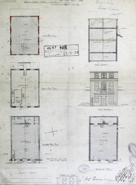
9) Architectural Drawing for the Reason Manufacturing
Company’s Robert Street works. Image courtesy of East
Sussex Record Office
In 1861, Thomas was documented as having moved to 14 Richmond Street. He was described as a Baptist Minister and his birthplace was listed as Weymouth. There is no mention of his wife and only Caroline of the younger children is listed, plus another child, Benjamin who is eight. By 1871 Thomas had moved to Richmond Street. He was still listed without a wife, and only Susannah, who was by then twenty-five, appeared to be living with him.
By 1881 he was remarried, to Ruth, who was twenty years his junior and living at 5 Pelham Square. In 1891, aged seventy-six, he was again recorded in Pelham Square but he was now married again, for a third time, to Sarah who was fifty-four.
Thomas died, aged eighty-four, in the final months of 1898 and, thereafter, the chapel closed after seeming to have been in decline through the 1890s. Thomas had led a very full life, married three times, fathered eleven children, and preached in a packed chapel for forty-seven years.
The Reason Manufacturing Company was established in the late nineteenth century and had premises in Gloucester Road from 1891; they eventually expanded into other premises in Sydney Street, Queens Road and Robert Street.
Set out in picture 9 are the beautifully detailed plans for the Reason Manufacturing Company’s Robert Street works, dated the 28th February 1898. The project is developing the former Chapel. The first two floors are referred to as workshops, and the plans show a new loft space, on a newly built third floor. They also show a crane on the outside of the building and the old first floor windows converted into doors to allow for a hoist.
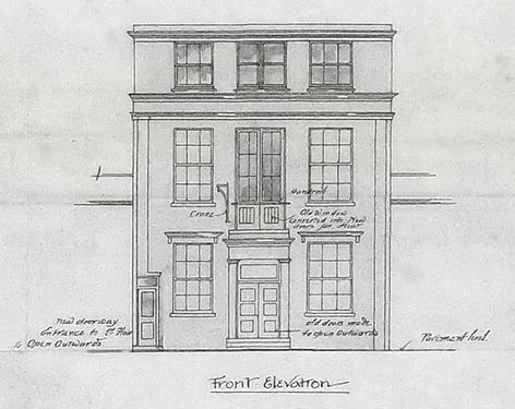
10) Close-up of the Reason Manufacturing Company’s
Robert Street works, illustrating the main elevation with
hoist. Image courtesy of East Sussex Record Office
The company was a toy and “fancy goods” depository, effectively a warehouse. They were also described as Mechanical Engineers. The company expanded fast; in the 1900 Towners Directory they seemed to also occupy numbers 15 and 18 Robert Street. The Reason Manufacturing Company evolved into the Brighton engineering firm of Allen West which eventually moved to Lewes Road. In the 1901 census the part of the street occupied by the former chapel and works was described as: Nos 15-18 “2 houses and a public hall”
There were to be several further changes of occupant and use to the structure in the following years: the Terry’s Manufacturing Company in 1904; a Marine Stores operated by WG Barnes and the Central Auction Rooms in 1906. The Auction Rooms proprietor of this last mentioned business was Edwin Tully and the last mention of his bussiness it, which can be found, is in the 1919 Pikes Directory. It then became a furniture depository, owned by William Stead, until 1926 when Price and Co., Bedding Manufacturers moved in.
The first mention of Price and Co., Bedding Manufacturers is in the 1927 Pikes Directory and this firm occupied the building until either 1966 or 1967. The company was started by Nellie Price, who lived at 43 Tidy Street, and was definitely in existence by 1891, and was purchased by Norman Stace in 1938. The company retained the name adding Regency in 1951. The 1954 Kellys Directory listing is Price and Co. (Regency) Ltd Bedding Manufacturers and upholsterers (trade enquiries only) Tel.Brighton 22169. The business still operates today and is based in Portslade.11
By 1960 the firm also included furnishing. The last occupier of this building, from the evidence in the street directories, was Patching Brothers, upholsterers who moved into the premises in 1968. Eventually in the 1980s, the building was converted into flats.
The old Argus printing works (now Argus Lofts) has long dominated the western side of the street. Yet nineteenth century maps all show the west side in use as a timber yard (see earlier 1875 1:500 O.S. MAP). The first mention of a printing works in the street is Robinsons Printing Works, in the 1905 Kellys Directory. By 1907, Robinsons Printing Company, is described, in the Pike’s Directory as being at numbers 28 and 29.
The first mention of Southern Publishing in a Directory is in 1915 but it is not until 1926 that the company – which printed the Argus - acquired the Robinsons Printing works and adjoining premises at the southern end of Robert Street. The Argus had previously been printed in North Street. Southern Publishing further extended their printing works in 1934, which necessitated the demolition of ‘the house with nine skulls’.
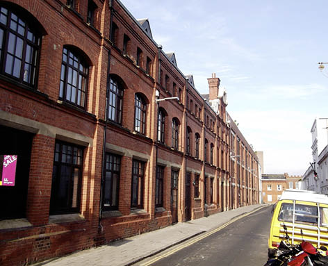
11) The Argus building before conversion to the Argus Lofts
Research into the old Argus building has not been helped by what seems to be the total lack of the records of Southern Publishing in the public domain, either at ESRO or at the Brighton History Centre. Searching on the Access to Archives website (http://www.nationalarchives.gov.uk/a2a/) also does not garner anything useful. The reluctance of the present management of the Argus to help with our research has also not been helpful; more work remains to be done in this area. A way forward could be an oral history project interviewing the people who worked there before the move to Hollingbury in 1992.
The Canteen public house was situated on the north western corner of the street, at its intersection with Gloucester Road. The pub was a Kidd and Hotblack house, established in 1885 and remained under their auspices until Tamplins took over in 1926.
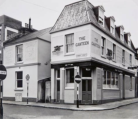
12) The Canteen public house. Image courtesy
of The Regency Society. For further details, see:
http://www.regencysociety-jamesgray.com
It was closed down in 1963. Tamplins' records reveal that they bought the land freehold on the 14th November 1885; “to purchase from Messrs. G Cheesman and Co. of Freehold land, with buildings on it, situate in Glo’ster Road and the corner of Robert Street.” They appeared to have held leasehold rights to this land, prior to 1885.12 John L. Wheeler was the landlord of The Canteen until 1903, after which his son Lovell J. Wheeler took over until 1940. The House Valuations Book for Kidd and Hotblack implies that the pub did exist before 1885 and that Wheeler took over from a Mr Gardner in 1883 but this is certainly not backed up by the directories which do not mention the pub before 1885.13
The pub would have served the local community, including the thirsty printers from Southern Publishing. As the pub’s name suggests, along with the cannon once mounted on the wall, it was also associated with the Headquarters of the 1st Sussex Volunteer Artillery across the road. The building was demolished in 1966 to allow for another extension to Southern Publishing’s premises.
The Canteen certainly seemed to have flourished during the Second World War. The total value of the trade in the year between February 1941 and 1942 was £1,255, but this increased to £4001 the following year. A proposed plan for an alteration to the Canteen Inn, dated the 15th January 1943, indicates that there was to be a modification to the public bar, the plan states that the changes were; “to allow more room near the entrance from Robert Street, as a congestion arises at times in consequence of a black-out arrangement at the entrance”. The work was completed a few months later though it had been “delayed through enemy action.”14
House of Nine Skulls This infamous building certainly deserves a mention. Although it is associated with Robert Street, it was actually the back wall of a builders’ workshop in Kensington Street. The origin of the nine skulls is unclear, and there are many theories surrounding their existence in the house. The most popular of these is that there was a boiler explosion and “the bodies of the nine men killed by it were found in a ring, eight with their heads pointing towards the centre of the ring and the ninth lying in the opposite direction.”15 To mark this tragic event the skulls were “carved into the wall,” unfortunately due to further extension to the Southern Publishing Company the house of the nine skulls was demolished in 1934.16
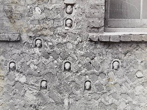
13) House of Nine Skulls. Image courtesy of The Regency
Society. For further details, see: http://www.regencysociety-jamesgray.com
Residents
The 1841 Census did not not give house numbers but an idea can soon be gathered of the street’s early residents, they were a mixture of: skilled artisans; upholsterers; wheelwrights; dressmakers; plasterers; straw milliners; labourers and domestic servants. From the beginning, many of the houses would have been multi-occupancy as can be seen in the 1851 Census.
In 1851 there were three families living in number 8 Robert Street; the Goldsmiths, the Nightingales and the Suttons. This made a total of sixteen people in one house. Most properties would not house as many, but three families, one on the upper floor, one on the ground floor and one in the basement would not, at this time, have been uncommon.
William Charman was a long standing resident of Robert Street. First mentioned in the 1867 Pages Directory, as living at number 13, he is described as a ‘bill poster and advertising agent.’ Charman’s business obviously flourished in the remaining years of the century and he was able to promote his activities with advertisements in local publications.
Charman is listed, in the 1901 Census as ‘a director of a building company’. At this time he was seventy-nine years old and still living at number 13 Robert Street. Interestingly, the billposting firm of Charman, Davey and Gallie had offices at number 24 Robert Street from around 1901 to as late as 1907. William Charman was last mentioned as living at number 13 in 1905.
Another long standing Robert Street resident and local businessman was Charles Suter who is variously described as a cork manufacturer and a cork cutter. He is first mentioned in the 1886 Walsers Directory and was still active in this trade in 1923 by which time he would have been over seventy.
The Jeals were at number 19 for over thirty years, as were the Tulls at number 7. There are many instances of families living in the street for over 20 years - the Cooks, Richardsons, and Salvages at numbers 1, 2 and 4 respectively for instance.
Most of the houses in the North Laine, including of course Robert Street, were rented and often in multi-occupancy until well after the Second World War. It was only in the 1970s that the area began to change from a traditional working class community to one with a more affluent middle class resident, often educated and possibly commuting to London.17
For most of its history, skilled workers and artisans have lived in Robert Street. Listed in the 1891 Census, amongst others, are: a plumber; a jeweler; a Battery Sergeant Major; a cork cutter; a print compositor; a wheelwright; a French polisher; a retired Chief Officer of the Coast Guard; carpenters; sign writers; fly drivers; bakers; bootmakers, and an electro plater.
An idea of family size and multi-occupancy figures can also be gained from looking at the 1891 Census. There are twenty-three houses recorded in this Census, twelve of which have one family living in them and two with three families. Altogether there were 139 people recorded in the Census, with an average of just over 6 persons and 1.5 families per house. This is still more crowded than today but perhaps not the stereotype of excessive Victorian overcrowding of which we hear so much. Indeed there were many families who lived in the same house for very lengthy periods: Charman at number 13 has already ben mentioned as have the Suters, the Jeals were at number 19 for over 30 years, as were the Tulls at number 7. There are many instances of families being there over 20 years: for instance the Cooks, Richardsons, Salvages at numbers 1,2 and 4 respectively. So Robert Street was a very fixed population on the whole in a variety of skilled occupations: the epitome of the respectable working class community.
The children would have attended the local board schools, which developed after 1870. A detailed search of the log books, admission and day registers is still to be undertaken but suffice it to say that many would have attended the Pelham Street Infants, Boys and Girls schools; the old National School in Church street and the York Place schools, which were effectively the first secondary schools in the town, later evolving into Varndean, the old Fawcett school and Margaret Hardy.
So we have a picture of a socially cohesive community. Although there have never been any shops in Robert Street itself, there was a wide selection of shops catering for everyday needs in Gloucester Road, North Road and Sydney Street. A directory for 1895 shows there were five butchers, three greengrocers and three bakers. There were also fishmongers, a fried fish dealer, four tobacconists, numerous pubs but also a temperance bar! The longevity of people living in the street supports this. Already mentioned, amongst others, are the Suter family at number 6, the Tulls at number 8 and the Charmans at number 13. This trend became even more apparent in the middle part of the twentieth century, as can be seen in the table.
These are some surprising details revealed in this table, for example, the eight families with the longest residency have a combined presence in the street of 458 years. These people would have known each other’s families across multiple generations. It would be wonderful if these former residents, or their relatives, would get in contact, so that the residents of not only Robert Street, but the North Laine and Brighton could learn more about this, clearly popular, street.
Trade
The 1851 Census shows a changing occupational structure; foundry labourers; brass founders; tin plate workers and railway porters all appear, reflecting the industrialisation of the North Laine area and particular the emergence of two major employers - the Regent Iron and Brass Foundry in Foundry street plus the railway works for the London Brighton and South Coast Railway (LBSCR) next to the station.
The 1845 Brighton and Hove Directory lists William Gillam a Boot and Shoemaker at number 23; the 1846 Kelly’s Directory lists Mrs Hariett Brayne as a Straw Hat Maker at number 19; the Jireh Chapel at numbers 16 – 17 and Walter Gillam, once again at number 23. This is probably the same William Gillam mentioned in the 1837 Deeds referenced above.
Health and crime
A stereotype of working class communities through the period of our study is that they were crime ridden. This does not seem to be the case with Robert street.
The coroners’ reports also do not show much that is remarkable. The most striking entry concerns the death of Lucy Newman in 1924. She lived in the basement of number 20 and was in her seventies when she died from accidentally setting fire to herself. On the evening of Saturday 22nd November she ran into the street at approximately 9.55 shouting “Help, help” with her clothes on fire. Her son William Newman had seen her three hours earlier and had reported that she was in ‘good health.’
Two men, Alfred Lambert thirty-three of 27 Robert Street and Thomas Avey twenty-nine of 22 Robert Street had been talking in the street when they saw and heard Lucy. They tried to save her and put out the flames. Alfred, a machine driller, burnt and injured his left hand trying to save her; Thomas an unemployed tiler and slater took off his overcoat to try and put out the flames. A third man Alfred John Thompson of 9 Pelham Street was walking by, heard the cries and also came to the rescue, tearing off his shirt sleeve and wrapping his coat around Lucy. The fire brigade arrived within ten minutes, and an ambulance was called taking her to the Royal Sussex County Hospital where she died the following morning at 11.45. The inquest a few days later said she had “died from shock following severe burns caused by her having accidentally set fire to her clothing at number 29 Robert Street.” The three men each received £4 from the Coroner’s fund and were praised for their bravery.18
Events
One major event in Robert Street’s history occurred in 1999, when the Argus building caught fire, The Argus had moved out of the building in 1992 to their new headquarters in Hollingbury. The fire started in the roof on the 5th December 1999, this account is from the website of the North Laine Community Association.
Flames shot about 30ft high into the air, and North Laine residents called emergency services. The police were sufficiently concerned to decide to evacuate the terraced houses on the east side… The roof was in flames, and then gas cylinders inside the building exploded sending glass and debris into the street.19
Smoke billowed across the North Laine area and two fire fighters were injured whilst trying to curtail the fire. The roof of the building was almost totally destroyed and the cause of the fire was never discovered.20
The fire was a traumatic event but has helped to herald in the development of the Argus Lofts: a mixed-use development with workshops, flats and some small shops. The architectural practice responsible was Conran and Partners and the work was completed by 2003.
Conclusion
Robert Street, today, still contains fine examples of North Laine terrace housing; the Argus Lofts adds a touch of modernity, but without overpowering the true essence of the street. Robert Street is in the very heart of the North Laine not just geographically, but socially and historically. There is still much to learn about the past residents of the street, and it will be fascinating to find out more about the Argus building and the people who worked there. Let’s hope we can continue to build this history of this fascinating street.
References
- Berry, S., (2005), Georgian Brighton, p108. Phillimore: Chichester
- ESRO, Deeds of 25 Robert Street. ACC5722/5
- The Cheesman family builders on http://www.johnh.co.uk/history/cheesmanbuilders.htm [Accessed 8 May 2010]
- ESRO, Deeds of 25 Robert Street. ACC5722/5
- ibid
- Dale, A., (1976), Brighton Town and Brighton People. p. Phillimore
- ESRO, Alterations to 8 Robert Street, Brighton for Mrs K Thornton, 1 plan (310/1). amshh/AMS6649/4/26/7
- B.J.M., Shipley., (2001) The Lost Churches of Brighton and Hove. p. Optimus Books: Worthing
- Ibid. p.
- Information on the Jireh Strict Baptist Calvinistic Chapel and the Ecclesiastical Census courtesy of Emily Burgoyne of the Regent’s Park College and David Woodruff of the Strict Baptist Historical Society.
- Company Background on price-regency.co.uk/info/background [Accessed 20th August 2011]
- ESRO, Property Register 1871-1916. TAM 5/2
- ESRO, House Valuations Book 1924. TAM 5/4
- ESRO, Register of Rents and Revisions. TAM1/37/5 and PTS/2/9/762
- The House of the Nine Skulls on http://regencysociety-jamesgray.com/volume25/source/jg_25_179.html [Accessed 1st August 2011]
- ibid
- Mead, G., (2006), North Laine - From open fields to Bohemian quarter on http://www.mybrightonandhove.org.uk/page_id__6050_path__0p114p442p1247p.... [Accessed 14th July 2011]
- ESRO, Newman. COR/3/2/1924/133
- Brand, M., (1999), Fire in the Argus building - Not Chinese crackers on http://www.nlcaonline.org.uk/page_id__444_path__0p5p39p.aspx [Accessed 10th July 2011]
- ibid